The Choice of Location for Anıtkabir
With the idea to build a mausoleum that suits Atatürk’s supreme personality, a special commission was formed by the government to choose the location for the construction of Anıtkabir. Under the chairmanship of the Permanent Undersecretary of the Prime Ministry, this commission was consisted of General Sabit and Hakkı from the Ministry of Defense; the General Director of the Department of Construction, Kazım from the Ministry of Public Works; the Permanent Undersecretary Vehbi Demirel from the Ministry of Domestic Affairs and the General Director of Higher Education, Cevat Dursunoğlu from the Ministry of Education. The commission had its first meeting on December 6, 1938. The commission decided to ask the opinions of foreign and native scientists about Anıtkabir and to invite well-known people to the meetings in this field. Meanwhile, they also consulted the famous urbanization expert Prof. Jansen, who had formerly prepared the construction plan of Ankara and who was working in our country at the time; Prof. Holzmeister, the architect of the new building of the Turkish Grand National Assembly; Prof. Taut, the architect of the building of the Faculty of Language, History and Geography and Prof. Belling from the Fine Arts Academy. This commission held its second meeting on December 16, 1938.
As a result of the studies of the Prime Ministry Anıtkabir Commission, it was decided that the following places would be suitable for Anıtkabir: · Çankaya
· The Ethnography Museum
· The Hill behind the Grand National Assembly Building (Kabatepe)
· Ankara Castle
· Bakanlıklar (Area reserved for the Ministry of National Education)
· The Old School of Agriculture
· The Youth Park
· Altındağ (Hıdırlık Hill)
· The Atatürk Forest Farm
The choice of Atatürk’s eternal place of rest attracted much attention in the media and public. The subject was really important and required careful working. Criticisms of the choice of location can be summarized as follows:
The Atatürk Forest Farm
Those suggesting the Gazi Forest Farm for Anıtkabir supported that it was a promenade with a green environment and that Atatürk would be happy among the memories of his time if he were to be buried in a place established by him.
Those against the idea claimed that the Gazi Forest Farm was one of the major promenades for the residents of Ankara with its parks, restaurants and various amusement areas and that the burial of Atatürk in the Gazi Forest Farm would end the joyous life there.
Altındağ :
The major argument of the supporters of this suggestion was that Altındağ was the highest hill in Ankara and could easily be seen from all around the city.
The suggestion of Altındağ did not get much appreciation since Altındağ was a very steep hill and it would be hard for people to climb those slopes.
The Youth Park:
In the reconstruction plan of Ankara by Prof. Jansen, this area was determined to be a park. Therefore, if Atatürk were to be buried there, people would be deprived of a place of entertainment. Moreover, being the lowest area in Ankara, this area would not create the impact of eminence. This suggestion was not found appropriate by the commission either.
The Old School of Agriculture
The proponents of the land of the old School of Agriculture relied on a very significant memory. Atatürk had used the School of Agriculture as a residence when he came to Ankara from Sivas with the delegation of representatives of the Sivas Congress (December 27, 1919). He resided here during the most critical days of the War of Independence, and made some of his most important decisions here.
Building Anıtkabir in a place full of unforgettable memories of the National Struggle had a great meaning in terms of connecting the beginning and the end.
However, this place was not suitable for building a mausoleum. Building Anıtkabir here was not approved of due to its being far from the city center.
Bakanlıklar :
The land Ministry of Education is located today was unused at that time. However, it was not suitable since the area was both the busiest place of daily life and in the middle of the city.
The Ankara Castle:
Those who wanted Anıtkabir to be built here claimed the following:
“The monument to be built here can be seen from afar since the Ankara Castle is one of the highest places of the region. The castle is the symbol of Ankara and a famous monument of the city as well. Burying Atatürk in this treasure of history would suit his supreme personality.”
However, a lot of artists and scientists proposed these counter arguments:
"The Ankara Castle symbolizes the past with all its features. This castle was built by the Byzantines and expanded by the Seljuk’s. As the savior of the Turkish Nation and the founder of the Turkish Republic, Atatürk launched a new era. He symbolizes the future of the Turkish Nation rather than its past. Therefore, it is not right to bury Atatürk to an old monument which has completed its duty. He is a worthy man on his own. He needs no other historical support."
These opinions were also supported by the commission and they decided not to build Anıtkabir in the Ankara Castle.
Kabatepe :
Famous architect Professor Holzmeister, who designed the Çankaya Mansion and the Grand National Assembly, was the first to propose Kabatepe, which is behind the new Grand National Assembly building. However, this place was not accepted by the commission.
Çankaya :
The most appreciated among the proposed places for Anıtkabir was Çankaya. One can summarize the thoughts of the proponents of Çankaya as follows:
"Atatürk lived in Çankaya for many years. It is full of his memories. He loved Çankaya very much. He once said, "The place where my memories will continue to live is Çankaya." These words should be regarded as a testament. The plans and schedules of the Turkish National Struggle, the foundation of the Turkish Republic and the reforms that followed were all prepared here. For these reasons, Anıtkabir should be built in Çankaya and the memories of Atatürk should be kept alive."
This proposal was supported by many scientists and writers and the decision to construct Anıtkabir in Çankaya was about to be made.
A superior commission with 15 deputies was formed by the Grand National Assembly to determine the exact location of Anıtkabir. Falih Rıfkı Atay (Ankara), Rasih Kaplan (Antalya), Mazhar Germen (Aydın), Süreyya Örgeevren (Balıkesir), Refet Canıtez (Bursa), İsmet Eker (Çorum), Münir Çağıl (Çorum), Mazhar Müfit Kansu (Denizli), Necip Ali Küçükağa (Denizli), Nafi Atıf Kansu (Erzurum), Saim Ali Dilemre (Erzurum), Salah Çimcoz (İstanbul), Ferit Celal Güven (Seyhan), Tevfik Tarhan (Seyhan) and Mithat Aydın (Trabzon) formed the commission. Münir Çağıl was appointed as the president. Falih Rıfkı Atay, Süreyye Örgeevren and Nafi Atıf Kansu were appointed as the reporters and Perit Celal Güven was appointed as the record keeper. The commission firstly gathered on January 5, 1939 and examined the report of the special commission regarding the nine candidate places.
At the end of the investigation, when Çankaya or the Ethnography Museum was about to be chosen, the president of the commission said to the members, "You have examined the places suggested. The members may look for other places as well".
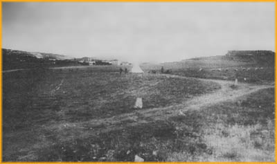
Rasattepe :
Specialist Engineer Mithat Aydın, the deputy of Trabzon, was looking for the most suitable place for Anıtkabir around Etlik, Keçiören, Cebeci and Altındağ. Finally, he went to Rasattepe where there were only a few buildings. This hill was in the middle of the city and its surroundings were empty. Anıtkabir, if built here, could be seen from afar.
At the last meeting of the commission on January 17, 1939, Mithat Aydın proposed Rasattepe as the location for Anıtkabir. He explained the features of the hill. However, the members having already agreed on Çankaya did not give up. Meanwhile, the Deputy of Antalya, Rasih Kaplan, said, “Friends, our friend having accomplished many things in our country is showing us a new place. How can we reject it without seeing it? What will our response be if Mithat Aydın speaks at the General Council tomorrow and says he suggested a place and we did not even look at it?” There were discussions upon this statement of Rasih Kaplan. The majority of the members wanted to see Rasattepe and decided to do so. The deputies went to Rasattepe and investigated the hill from various perspectives. They came to a positive conclusion. At the second meeting held on the same day, the deputies stated that Rasattepe was suitable for Anıtkabir. However, those decisive on Çankaya did not give up. Finally, Süreyya Örgeevren explained the appropriate features of Rasattepe and concluded his words as follows: “Apart from these, Rasattepe has another feature which might deeply interest anybody having a bit of imagination. According to the general overview of today’s and tomorrow’s Ankara, Rasattepe is like a star in the middle of a crescent that extends between Dikmen and Etlik, the two final points of Ankara. Ankara is the body of the crescent. If building Anıtkabir here is accepted, the following situation will occur. Türkiye’s capital city Ankara, with its arms wide open, will embrace Atatürk. By this way, we will lay Atatürk in the middle of the ‘star and crescent’ of our flag. Atatürk will symbolically unite with our flag.” The deputy of İçel, Emin İnankur, spoke after Süreyya Örgeevren and told them an anecdote about him. Emin İnankur was an old teacher whom Atatürk loved very much. Atatürk frequently walked around the city with him. They came across Rasattepe on one of their trips. After looking over the city from the hill, Atatürk said to Emin İnankur, “This hill is such a nice place for a monument”. After the statements of Emin İnankur and Süreyya Örgeevren, the building of Anıtkabir in Rasattepe was voted on. Eventually, Rasattepe was chosen as the location of Anıtkabir by a great majority. The decision was declared to the government and expropriation studies in Rasattepe were started on July 7, 1939.
The old name of Anıttepe was “Rasattepe”. There were few small buildings at the top of the hill before Anıtkabir was constructed here. They were used as observation (meteorology) stations. The name “Rasattepe” was given for this reason. The residents of Ankara called it “Five Hills”. This name came from the tumulus here.
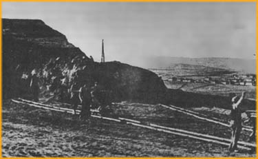
The tumulus here had to be removed once the decision had been made to construction Anıtkabir in Rasattepe. For this purpose, a commission was formed with the help of the Turkish Historical Society under the chairmanship of archaeologist Dr. Tahsin Özgüç, one of the associate professors of the Faculty of Language, History and Geography. This commission, in which archaeologists of the General Administration of Museums participated, made excavations in Rasattepe. In the light of the excavations, it was understood that these tumulus belonged to the Phrygians.
The Phrygians had come to Anatolia at the beginning of the 12th century BC during the migration of the tribes. The capital city of the Phrygians, who brought down the Hittites and founded a new state, was Gordion, which is close to Polatlı. Many artifacts belonging to Phrygian princes, princesses and kings were found in the excavations of the tumulus around Gordion.
The tumuli in Rasattepe were graves in the shape of rooms dug into soil like the ones in Gordion. The body, lots of possessions, arms and food thought to be used in the other world were put inside the room. The grave was covered with thick logs, and finally soil was heaped up on it forming a small hill. Artifacts unearthed from these tumuli are exhibited today in the Museum of Anatolian Civilizations in Ankara.
In his speech he made during the budget discussions at the Turkish Grand National Assembly on May 23, 1939, Prime Minister Refik Saydam stated that the land survey of Rasattepe had been completed and it was determined that some parts of the area belonged to the state municipality and individuals. The area of the land and its borders were measured and the required maps were drawn. Moreover, the Prime Minister said that 205,000 TL as the price of legal expropriation and 45,000 TL as the price of the international project competition which led to a total of 250,000 TL were granted and 287,000 square meters of land was to be expropriated. The expropriation of Rasattepe was determined on July 7, 1939 by Turkish Grand National Assembly.
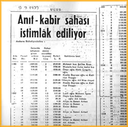
The plan prepared for the expropriation of Rasattepe was accepted by the Council of Ministers. The Permanent Undersecretary in the Prime Ministry, Vehbi Demirel, who was chosen as the chairman of the commission of expropriation, sent a notification to the Municipality of Ankara for the expropriation of the area. The expropriation announcement for 214.878 square meters in 1939 and 188,334 square meters in 1940 of the area of Anıtkabir was published on September 5, 1940, in an issue of the Ulus Newspaper.
According to Act 1463 of the government dated April 20, 1940, a total of 542,827 square meters land (459,845 square meters from individuals; 43,135 square meters from roads and parks; 28,312 square meters from the treasury; 3,044 square meters from schools and police stations; 8,521 square meters from individuals) was to be expropriated.
Further expropriations were made to extend the area by Act 3/78 dated November 23, 1943 and Act 3/671 dated June 27, 1947 of the government. By Act 3/6762 dated December 25, 1947, an additional area of 153,272 square meters was expropriated. 92,278.5 square meters of this area belonged to individuals, 6,178 square meters to roads of the municipality, 48,568 square meters to parks of the municipality, and 6,247.5 square meters to the treasury.
Only 27,108 square meters of the 92,278.5 square meters of the area of Anıtkabir that belonged to individuals could be expropriated due to insufficiency of funds. The remaining 65,120 square meters area that belonged to individuals was not expropriated in order to save 1,000,000 TL and prevent any injustice suffered by owners of the land by Act 11928 of the government dated September 21, 1950.
As a result of the expropriation in 1964 and 1982, two parcels at the intersection of Akdeniz Avenue and Marshall Fevzi Çakmak Avenue and 31,800 square meters land between the Mebus Evleri District and Marshall Fevzi Çakmak Avenue were added to the land of Anıtkabir, respectively.
To determine whether Rasattepe could stand the pressure of a 50,000 ton building, Prof. Salih Sayar from İstanbul Technical University was appointed by the Ministry of Public Works to carry out an investigation of "Foundation Mechanics" with the use of modern methods. In his report of May 18, 1945 presenting the results of his studies, Prof. Salih Sayar stated that Rasattepe, with an altitude of 907 meters, was the remains of a terrace over an area of alluvium and it was formed during the first phases of the Fourth Period. In the groundwork investigations of Anıtkabir's area, drillings were made reaching down to 40 meters and big spaces (galleries) were discovered inside the hill.
Especially, the cavities found under the Hall of Honor in Anıtkabir made it compulsory to apply different techniques in the foundation. The construction required to support the foundation was projected by the architects and engineers monitoring the construction works and sent to the ministry of Public Works. The Ministry of Public Works accepted the project. Moreover, it was decided to place the foundation of Anıtkabir under the ground like the tank of a ship enclosed with iron beams and wires.
To examine the state of foundation and construction of Anıtkabir, a committee meeting was held with the participation of representatives of the Ministry, Prof. Emin Onat and professors from İstanbul Technical University on February 12, 1946 at the Ministry of Public Works. In this meeting, it was concluded that Rasattepe was suitable for the construction of Anıtkabir and it would be right to construct it with reinforced concrete and stone by preserving the architectural features of Prof. Onat’s project so as to decrease the pressure of the building on the base and to increase the durability of the building in case of an earthquake.
Anıtkabir had to endure earthquakes. The Ministry of Public Works had this situation examined by a commission formed with its experts and professors from İstanbul Technical University. This commission declared the results of it
s long examinations in a report dated December 12, 1948. The report briefly included the following terms: “The city of Ankara is located completely outside the seismic zone according to the seismic map of the time. Nevertheless, the commission decided to compute the effects of an earthquake on this structure considering the reflections of earthquakes in the close regions of Ankara, the width of the area occupied by Anıtkabir and the seismic land of the architectural project. In this respect;
- The structure should be as light as possible. This condition must be satisfied especially in the elevated parts of the building.
- An occasion of a landslide seems probable in case of an earthquake since the land under Anıtkabir is a hill made of alluvium. Therefore, the upper building and foundation should be built as a concrete structure.
- It is essential to plant trees on the slopes of Rasattepe to prevent land deformation.”
All these reports made it compulsory to scrutinize the project and take the necessary precautions by making no changes on the external architecture of Anıtkabir. The foundation of the building would be a mixture of iron and reinforced concrete and the upper part would be a single piece. Thus the project was closely examined and all precautions put forward by the technical report were taken. The foundation of Anıtkabir was placed under the ground, like the tank of a ship under water, according to the project presented to the Ministry of Public Works and in the light of foundation investigations. In this way, Anıtkabir was made to endure the impacts of nature.